I've been making maps for years...and there isn't half a hope I could pull this off. Hats off to Franken!
Tuesday, October 20, 2009
Thursday, October 15, 2009
Blog Action Day: Climate Change and Sea Level Rise
This post is one of the 9,721 blogs that have been written in celebration of Blog Action Day.
 (North Carolina's Outer Banks, with a marker identifying Manteo, NC. Image taken from Google Earth. )
Welcome to Manteo.
I've never been here, but during my second year as a student in UC Berkeley's Department of Landscape Architecture and Environmental Planning I became intimately familiar with with this small 1,000+ person town. You see, Manteo is at a very low elevation. Located on the 8-mile long Roanoke Island, Manteo's elevation ranges from sea level to 20ft. It's mild topography is punctuated with marshy outcrops, soft beach slopes, and sun-warmed humic soil. Developed as a touristy 'second-home' town, Manteo is a beloved summer resort for many North Carolina residents. Full of Native American and English colonial history (i.e. Roanoke Island was home of the first English settlement, the famed 'Lost Colony'), bird nesting grounds, and ample beach access, Manteo is the spot to be in the warm pre-hurricane months.
Or at least, for a few more years it will be...
Manteo's low elevation (and that of it's protecting eastern islands) makes it particularly vunerable for climate-induced sea level rise. The Intergovernmental Panel on Climate Change (IPCC) estimates that changes in the earth’s climate could raise global sea levels by one to more than two feet over the next 25 to 75 years. On the North Carolina coastline, that could mean complete inundation of all North Carolina barrier islands within the next 100 years... Manteo included.
Recent research conducted at the The University of North Carolina Wilmington shows that the impacts of sea level rise on North Carolina's coastline could be disastorous on North Carolina's "property values, recreation, and quality of life". To summarize the findings, the study found:
The economic and ecological findings of this study struck a chord with one of my professors at Berkeley. As a North Carolinian native, my professor dispatched his entire graduate class of planning students on a 5-week assignment to do what could be "done" to save his beloved Manteo and it's neighboring beach islands. It was a difficult assignment to say the least. What does somebody do for a town that is going to be 3 ft under water by 2100? There were many caffine-induced talks of floating cities, stilted buildings, sea walls, relocation of bird sanctuaries, and then...
I made things a little worse.
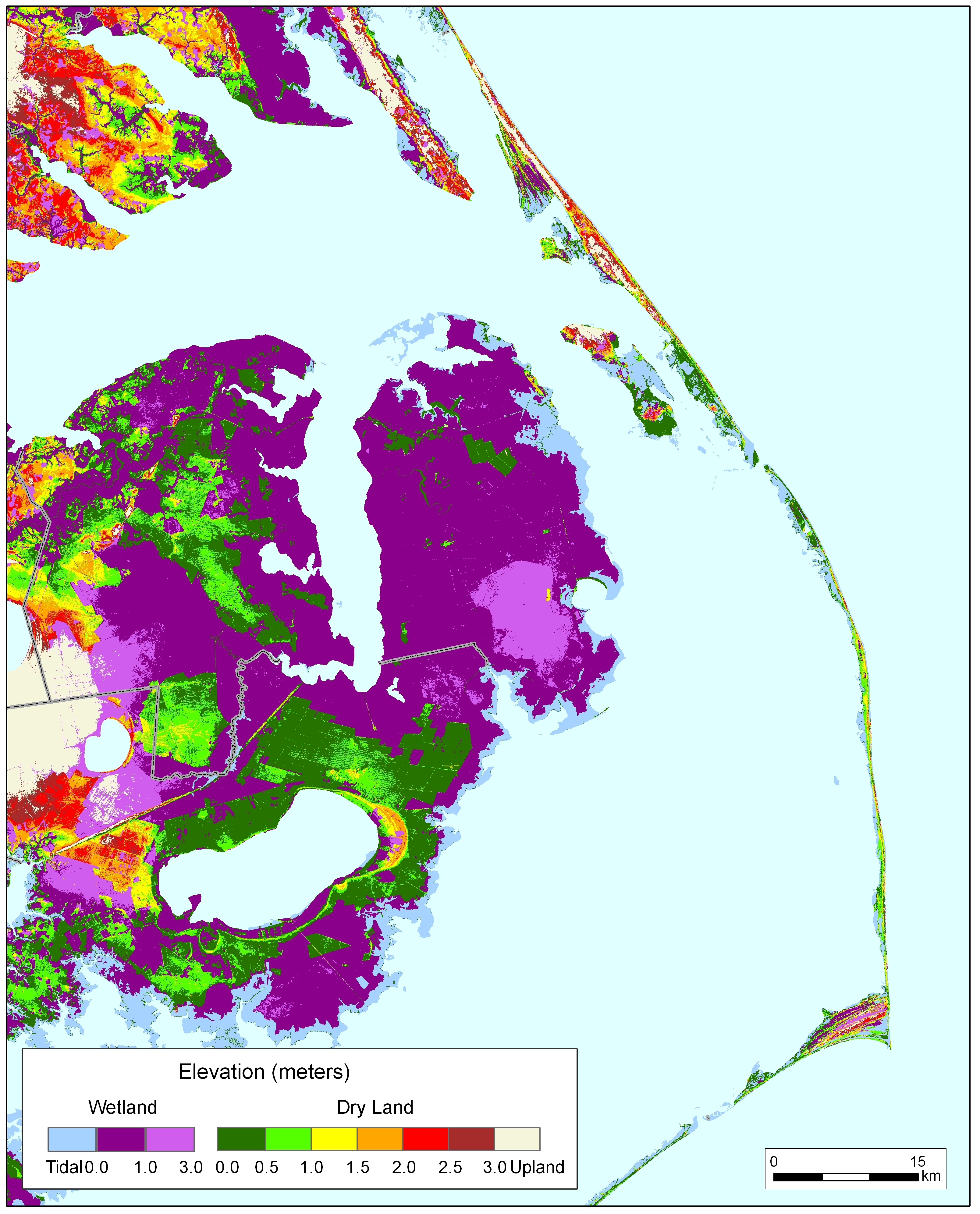
On a whim, while running the GIS figures for coastal erosion, I took a look at what was happening west of Manteo. While my class was focused on the islands (and Manteo, specifically) I GIS-ed my way towards the Albemarle Sound and the inland land masses. Caculating just for sea level rise (and not adding in the average 50 to 100 feet of land lost for every foot of sea-level rise), I produced these maps:
 (50-yr Sea Level Rise)
 (100-yr Sea Level Rise)
My professor's were stunned. The increase in the Sound size was highly unexpected, and not mention, none of our previous research and literature suggested that this was going to happen (indeed, all of our maps regarding Dare County coastal flooding/land loss were focused on the coast not the inland). Suddenly, we were not just dealing with your typical million dollar vacation-home, beach-property, bird-sanctuary, tourism-industry 'global warming' problem. We were dealing with the potential loss of valuable farmland, nonriverine peatland, permanent residences, highway/bridge developments, and the relocation of 100,000+ residents 60 miles inland from the initial study site. All set to occur within the span of 100 years.
If we thought our first case scenario was challenging...this was definitely a new story. Questions became more stressed and confounding. For example: even if we did build a sea wall strong enough to protect island residences from savage hurricanes and sea level rise, how in the world would tourists get to their vacation homes when it would mean constructing a 60 mile bridge? How would we feed these tourists when all the local farms were sitting under the new Sound? How and where would we provide water and electricity to these islands?
The cost estimates of all our plans and disaster scenarios easily cleared billions and trillions of dollars. By the end of our 5-week assignment, everyone was exhausted from the stress of trying to confront and deal with a million different economic and ecological landscape woes. Even the hardcore environmentalists among us were ready to take a break and move on to planning something--ANYTHING--other then the North Carolina-version of Atlantis. We wanted to do something cute, easy, and short-term. Like a golf course or a playground slide.
However, this one assignment definitely had a long-lasting impact on me. Climate-induced sea level rise is a problem that is going to affect a lot of people. Even people who do not live near the ocean are in imminent danger. Our ways of life, communication, and perception need to change immediately, so that we can begin to fully envision and perceive the change that is upon us.
It's only when we know the full scope of the problem that we can truly begin to resolve it.
Today, on Blog Action Day, I encourage you to take the first step in understanding how vast this problem is, and how vast our global response must be.
 (North Carolina's Outer Banks, with a marker identifying Manteo, NC. Image taken from Google Earth. )
Welcome to Manteo.
I've never been here, but during my second year as a student in UC Berkeley's Department of Landscape Architecture and Environmental Planning I became intimately familiar with with this small 1,000+ person town. You see, Manteo is at a very low elevation. Located on the 8-mile long Roanoke Island, Manteo's elevation ranges from sea level to 20ft. It's mild topography is punctuated with marshy outcrops, soft beach slopes, and sun-warmed humic soil. Developed as a touristy 'second-home' town, Manteo is a beloved summer resort for many North Carolina residents. Full of Native American and English colonial history (i.e. Roanoke Island was home of the first English settlement, the famed 'Lost Colony'), bird nesting grounds, and ample beach access, Manteo is the spot to be in the warm pre-hurricane months.
Or at least, for a few more years it will be...
Manteo's low elevation (and that of it's protecting eastern islands) makes it particularly vunerable for climate-induced sea level rise. The Intergovernmental Panel on Climate Change (IPCC) estimates that changes in the earth’s climate could raise global sea levels by one to more than two feet over the next 25 to 75 years. On the North Carolina coastline, that could mean complete inundation of all North Carolina barrier islands within the next 100 years... Manteo included.
Recent research conducted at the The University of North Carolina Wilmington shows that the impacts of sea level rise on North Carolina's coastline could be disastorous on North Carolina's "property values, recreation, and quality of life". To summarize the findings, the study found:
- North Carolina’s coastal topography makes it especially vulnerable to sea level rise and hurricanes—both economically and ecologically.
- A one- to three-foot rise in sea level along four North Carolina coastal counties could mean billions of dollars in private property losses.
- Recreational fishing and beach trips also are vulnerable to increased erosion from sea level rise and increased hurricane severity/frequency.
- Business interruption losses from hurricanes could increase by as much as $157 million per storm event by 2080.
The economic and ecological findings of this study struck a chord with one of my professors at Berkeley. As a North Carolinian native, my professor dispatched his entire graduate class of planning students on a 5-week assignment to do what could be "done" to save his beloved Manteo and it's neighboring beach islands. It was a difficult assignment to say the least. What does somebody do for a town that is going to be 3 ft under water by 2100? There were many caffine-induced talks of floating cities, stilted buildings, sea walls, relocation of bird sanctuaries, and then...
I made things a little worse.
On a whim, while running the GIS figures for coastal erosion, I took a look at what was happening west of Manteo. While my class was focused on the islands (and Manteo, specifically) I GIS-ed my way towards the Albemarle Sound and the inland land masses. Caculating just for sea level rise (and not adding in the average 50 to 100 feet of land lost for every foot of sea-level rise), I produced these maps:
 (50-yr Sea Level Rise)
 (100-yr Sea Level Rise)
My professor's were stunned. The increase in the Sound size was highly unexpected, and not mention, none of our previous research and literature suggested that this was going to happen (indeed, all of our maps regarding Dare County coastal flooding/land loss were focused on the coast not the inland). Suddenly, we were not just dealing with your typical million dollar vacation-home, beach-property, bird-sanctuary, tourism-industry 'global warming' problem. We were dealing with the potential loss of valuable farmland, nonriverine peatland, permanent residences, highway/bridge developments, and the relocation of 100,000+ residents 60 miles inland from the initial study site. All set to occur within the span of 100 years.
If we thought our first case scenario was challenging...this was definitely a new story. Questions became more stressed and confounding. For example: even if we did build a sea wall strong enough to protect island residences from savage hurricanes and sea level rise, how in the world would tourists get to their vacation homes when it would mean constructing a 60 mile bridge? How would we feed these tourists when all the local farms were sitting under the new Sound? How and where would we provide water and electricity to these islands?
The cost estimates of all our plans and disaster scenarios easily cleared billions and trillions of dollars. By the end of our 5-week assignment, everyone was exhausted from the stress of trying to confront and deal with a million different economic and ecological landscape woes. Even the hardcore environmentalists among us were ready to take a break and move on to planning something--ANYTHING--other then the North Carolina-version of Atlantis. We wanted to do something cute, easy, and short-term. Like a golf course or a playground slide.
However, this one assignment definitely had a long-lasting impact on me. Climate-induced sea level rise is a problem that is going to affect a lot of people. Even people who do not live near the ocean are in imminent danger. Our ways of life, communication, and perception need to change immediately, so that we can begin to fully envision and perceive the change that is upon us.
It's only when we know the full scope of the problem that we can truly begin to resolve it.
Today, on Blog Action Day, I encourage you to take the first step in understanding how vast this problem is, and how vast our global response must be.
Wednesday, October 14, 2009
Computers, K-12 education, and GIS

Recently, I ran across an interesting (but old, 2005) article by one of my favorite bloggers: Atanas Entchev. It was an editorial, in Directions Magazine, called "What Makes a Perfect GIS Job Candidate?". In the article, Entchev asks:
What makes a perfect GIS job candidate? Good education or good training?
...and ultimately concludes
Education and training are complementary, but distinct. Education is important, especially in the long run. But training is necessary, too.
I like Entchev's discussion on this and I also find it to be exceptionally true. GIS is something that takes learning both from the classroom and in the field to really master. I've definitely found this to be the case in my academic and professional life. However, one unfortunate fact remains that without classroom training, it's very unlikely that you will get professional training. In my experience, there really is no chicken-and-egg debate on obtaining computer skills. If you want a GIS (or any computer related job), you need to: 1) go to school for it and then 2) pick up the industry experience after you graduate. The real question is: when should students begin their GIS training?
These days, getting the initial academic training for GIS is relatively easy, provided you have access to a community college/university and a decent computer station. If you don't: then you are in trouble. Which is unfortunate, because GIS training can open doors to thousands of jobs and a multitude of different career pathways. It also is a great way to gain geographical literacy and improve spatial skills, something that young American's are showing an alarming lack of (according to the 2006 Roper survey, half of the 18-24 year olds surveyed couldn't find New York on a map). Studies have also shown that GIS has the potential to "improve problem and enquiry-based learning" and advance critical thinking skills in young children (Tschirner and O'Brien 2006, Hall-Wallace and McAuliffe 2001).
As a GIS specialist, encouraging young (and soon-to-be-working) K-12 students to learn GIS, is an important life goal for me. This might seem strange, given that I myself didn't learn about GIS till my final years of undergrad, and didn't gain mastery of the software till graduate school. However, my lack of early life computer skills and my current awareness of how important GIS is to the workforce, has made me all the more determine to advocate it's full-integration into K-12 public education system. I began this campaign little over a year ago, by holding GIS and geography technology workshops in an inner-city West Oakland high school as part of my work as an Albert Schweitzer Fellow.
During my work at Excel, I noticed a few things about today's K-12 students and their computer skills that I did not expect to notice. For one, I noticed that almost all the students I met had far more access to computers then I ever did at their grade level. Where as I learned typing skills on 10-year old typewriters, all my students learned how to type with word processors. I also noticed that my students were aware of computer 'lingo' in a way I never was at there age. They could easily tell the difference between a Mac and a PC, and were very informed about different internet sites, web browsing, and social networking.
However, for all their advanced computer skills, these 11th and 12th grade students did have some noticeable training gaps. In my earliest work with them, I quickly noticed that many of the students had rudimentary to non-existent geographical skills. Many of them did not know how to read a map, and couldn't tell the difference between a topo line and a rhumb line. We had to go over what a projection, what a datum was, what scale was...and, well, everything.
Looking back, I guess I shouldn't have been too surprised about my students imbalance of skills. In 1998, it was reported that 55% of American's owned a home computer. That number was up to 76% in 2005. Current reports show that more than 90% of students in grades 6-12 use computers regularly during school hours. However, starkly contrasting with the increase of computer skills is the steady decline of basic geographical training in our K-12 system. As early as 1979, researchers have notice that the "geographic knowledge of high school students is inadequate and that enrollment and achievement in geography education are low" (National Assessment of Educational Progress, 1979). This decline was particularly noticeable in the years when I was a K-12 student (80's-90's), when researchers found that only 16% of sampled high school students had taken a geography class (National Commission on Excellence in Education, 1983).
Recent data on the geographic performance of fourth, eighth, and twelth graders (see The Nation's Report Card: Geography 2001) shows a slight trend towards improvement in K-12 geographic training since 1994 (particularly for fourth and eighth graders). But that improvement appears to favor a particular racial and economic demographic. As the report shows, "the average score for students who were eligible for the Free/Reduced-Price School Lunch program was lower than the average for students who were not eligible for the program (i.e. above poverty guidelines)". Furthmore, inner-city kids appear to be at a distinct disadvantage, with "students in rural and urban fringe locations [having] higher average scores than central city students".
My year of work with the Excel students was definitely an eye-opening experience about what public education is currently offering lower-income students on the topics of computer skills and geography. On one hand, all my students were far more computationally advanced then I was at their age (and, thanks to a generous donation from Dell, they had many more on-campus computer resources then I did at their age). However, on the other hand, they were still suffering (as much as I was at their age) from the obvious decline of geographic training in our K-12 system.
I'm not going to make a fool of myself here and declare that everyone of my students wanted or was well-suited to pursue a career in GIS (many were not interested). However, the fact of the matter is we live in a digital world where computer skills are necessary for job placement and for everyday life. Furthermore, in order to have a competitive advantage in the employment market, students need more then just your average IT skills (i.e. typing, web browsing) that were standard K-12 learning fare in the 80's and 90's. In order to have the competitive edge, students today need to have computer skills that enable them to treat computers as analytical tools and not as mere data storage (or facebook-frenzy) devices. Furthermore, in our digital world, where geographical boundaries are being made shorter everyday, it is important to keep striving to improve geographical literacy in our K-12 students. To fail to do so, would only place the US labor and intellectual market further behind it's international competitors.
GIS can accomplish these tasks. Not just for the poor students, but for every student. In an education system where approximately 93% of geography teachers had degrees in education (note: only 28% had a degree in geography), GIS offers a (relatively, when compared to teacher re-training) low-cost and immediate way to jump start a large-scale US geographical curriculum. By combining computer training with geography lessons, teachers have a way to kill "two birds with one stone". Students will learn to use an industry-based software program that goes beyond the usual drill-and-practice educational software. At the same time, students will also increase their spatial-thinking and critical thinking skills, and gain introduction to basic geographical concepts (which notably, research shows that students who used computer tools even to a small or moderate extent had higher geography scores than students who did not use these tools at all).
I'm not assuming that implementation of this will be easy (it won't be....afterall, there is buying the software, making sure you have enough computers, sufficient IT help, etc etc). However, I think introducing a software into an existing K-12 classroom/curriculum structure is way better (and easier) then adding a new class or teacher to the K-12 curriculum. The beauty of GIS is in the vastness of it's applicability. Anyone (not just a geography class) can offer training in it, since so many fields use it.
End of story: GIS is a good idea for solving many of the current problems in the K-12 system. I hope my kids get a chance to learn it there, rather then having to wait to learn it in college (like I did).
Thursday, October 1, 2009
Why Space? (aka "get a new PR department NASA")

Earthrise. December 24, 1968.
A few years ago, Elon Musk, stood before Congress and pointed out that the powerful dream and institution that once committed roughly two to four cents out of every U.S. tax dollar, employed up to 409,000 workers, and succeeded in having American's land on the moon was dying.
His reason? Normal people couldn't afford to make it into space.
Well, no disrespect to Mr. Musk, but I'm not sure that's the real reason. In fact, given that a lot of American's (like myself) are afraid of heights, I doubt many of us want to go into space-- even if we could afford it. Heck, I suspect the whole operation of getting people up there (even if it was cheap) would be highly unpleasant. It's cold (something every Californian fears), I hear there are no coffee shops (something every researcher needs), and I don't like how those white suits make my butt look (something every women is secretly thinking about).
Basically, I think Musk is assuming a lot by saying "every" American wants to go to space. However, he has a point in saying that the space program is in decline. It is a well-known fact that America's prominence in space is under siege. The signs are everywhere: decreased federal spending to NASA (NASA's current budget is little over 1/2 of what the budget was during the NASA's 1966 Apollo peak--in current dollars and utterly incomparable to what American's currently spend on pizza). The prolonged layoff of our current shuttle fleet (How's this for some Cold-War irony? If the US wants a ride to the space station we helped build, we are going to have to hitchhike with the Russians. ::insert one big Werner von Braun laugh here::). Continued project delays, China and India's new breakthroughs...add it all up, and it spells one, big, clear message: "Houston, we failed".
But, is the reason this is all happening because the U.S. public has stopped dreaming of space? Or is this (very real) disinterest tied to something else? Is it just a symptom of the cause? Is the incomprehensible cost and feat of taking an ordinary American to space, doing what Musk suggests: stifling our dreams and stopped us from striving?
My answer is no. I think American's are very interested and inspired by space exploration and space related technology. For evidence, look at how the most classic story of space exploration--Star Trek--did in the movie theaters this year (fyi, it was the 8th highest-grossing film of 2009).
Still not convinced? Okay. Think those dollars reflect more about Chris Pine's 'stumble-and-grin' line delivery then how the nation feels about space exploration? Fair enough. I'd really like to cite the rave reviews of Hubble 3-D in Imax as further case-and-point to this argument...however, that won't be released till next year. So, in lacking better evidence, I'll just google up some recent headlines, like:
1) The MIT kids who launched a $150.00 space balloon...
2) ...and the IOS's work to create an 8,000 launch price for personal satellites...
3) ...and Bolonkin's idea for a High G-force Magnetic Space Launcher (think: big techno slingshot in the middle of somewhere large and remote...like that space between George W's ears....how freaking cool is that)?
For me, these are all prime examples of U.S. innovation currently taking place to feed our healthy and robust space interest. Because space exploration is cost-prohibitive, there are indeed a slew of students, private industries, and professors currently dedicating their lives to creating the next affordable taxi cab to Mars. Furthermore, because funding is bad, many of these people are performing these feats of brilliance for far less money then what the newest blond is making on the reality show "The Hills" -- which, to me, only emphasizes how dedicated these individuals are to making space a national priority.
However, what about the "other" folk? The folk without the PhD's, corporate funding, and MIT's resources? What about the "public opinion"? Why are there polls saying that space exploration isn't a public priority anymore and why is public opinion being held responsible for the recent reductions in federal research funds (because, as Abraham Lincoln once eloquently put it, “Public opinion in this country is everything”)?
Quite simply, I don't think the public clearly understands what space research is, how much it does (and is doing), and how important it's going to be for helping us tackle the pressing issues that trouble us here on Earth.
Maybe it is because NASA only get's 1% of the overall federal budget, but their PR engine is pretty bad. Atrociously bad in fact. Most people seem to associate NASA with rocket launching and space walks and are completely unaware of the numerous social benefits that NASA has contributed to. To emphasize this fact, in 2007, USA Today offered a list of the “Top 25 Scientific Breakthroughs” that occurred in it the past 25 years. Of these 25 breakthroughs, nine of these came from space, eight directly from NASA. Michael Griffin, on NASA's website, is quoted saying:
“We see the transformative effects of the Space Economy all around us through numerous technologies and life-saving capabilities. We see the Space Economy in the lives saved when advanced breast cancer screening catches tumors in time for treatment, or when a heart defibrillator restores the proper rhythm of a patient’s heart….We see it when weather satellites warn us of coming hurricanes, or when satellites provide information critical to understanding our environment and the effects of climate change. We see it when we use an ATM or pay for gas at the pump with an immediate electronic response via satellite. Technologies developed for exploring space are being used to increase crop yields and to search for good fishing regions at sea.”
As a remote sensing specialist, I cannot agree with Michael more. I personally "see" the effects of space travel all around me. It is heart and soul of my own life, and with me in (almost) all of my cartographic work. In fact, I still remember the moment, when looking at the Earthrise photo in my first GIS textbook, when I realized that Armstrong's walk might have been a cool journey, but his photos were the real discovery.
Thanks to space technology, I am able to map our planet and it's inhabitants in a manner that would've never been possible had we kept our feet (and funding) on Earth. By doing this I am able to generate information and insight that not only creates cool maps, but serves the U.S. by providing cheap, critical, and strategic information about key public interests which (unlike space exploration) did happen to make the 'priority' list (such as defense, clean energy, environmental concerns, economic development...just to name a few).
Thanks to space technology, I also don't need to be in space to perform this job either. Which is good, because I still don't think I want to go.
Which brings me to my point. Considering that everytime a United States citizen sleeps on a Tempur-Pedic bed, or contemplates neurosurgery, or answers their cell phone...we are experiencing a benefit that we can thank NASA for, I'm going to go out on a limb here and say NASA just needs a new PR department. Not a special discount on space tickets.
I mean, really Mr. Musk, with all the things NASA has done on Earth, why do any of us need to leave the neighborhood to see the local improvements? The value of exploring space is all around us, just as the dream is clearly alive in every sci-fi movie, book, and game we have in circulation.
The only thing missing here, Mr. Musk, is the "Courtesy of NASA" stamp.
Subscribe to:
Posts (Atom)

