 (North Carolina's Outer Banks, with a marker identifying Manteo, NC. Image taken from Google Earth. )
Welcome to Manteo.
I've never been here, but during my second year as a student in UC Berkeley's Department of Landscape Architecture and Environmental Planning I became intimately familiar with with this small 1,000+ person town. You see, Manteo is at a very low elevation. Located on the 8-mile long Roanoke Island, Manteo's elevation ranges from sea level to 20ft. It's mild topography is punctuated with marshy outcrops, soft beach slopes, and sun-warmed humic soil. Developed as a touristy 'second-home' town, Manteo is a beloved summer resort for many North Carolina residents. Full of Native American and English colonial history (i.e. Roanoke Island was home of the first English settlement, the famed 'Lost Colony'), bird nesting grounds, and ample beach access, Manteo is the spot to be in the warm pre-hurricane months.
Or at least, for a few more years it will be...
Manteo's low elevation (and that of it's protecting eastern islands) makes it particularly vunerable for climate-induced sea level rise. The Intergovernmental Panel on Climate Change (IPCC) estimates that changes in the earth’s climate could raise global sea levels by one to more than two feet over the next 25 to 75 years. On the North Carolina coastline, that could mean complete inundation of all North Carolina barrier islands within the next 100 years... Manteo included.
Recent research conducted at the The University of North Carolina Wilmington shows that the impacts of sea level rise on North Carolina's coastline could be disastorous on North Carolina's "property values, recreation, and quality of life". To summarize the findings, the study found:
- North Carolina’s coastal topography makes it especially vulnerable to sea level rise and hurricanes—both economically and ecologically.
- A one- to three-foot rise in sea level along four North Carolina coastal counties could mean billions of dollars in private property losses.
- Recreational fishing and beach trips also are vulnerable to increased erosion from sea level rise and increased hurricane severity/frequency.
- Business interruption losses from hurricanes could increase by as much as $157 million per storm event by 2080.
The economic and ecological findings of this study struck a chord with one of my professors at Berkeley. As a North Carolinian native, my professor dispatched his entire graduate class of planning students on a 5-week assignment to do what could be "done" to save his beloved Manteo and it's neighboring beach islands. It was a difficult assignment to say the least. What does somebody do for a town that is going to be 3 ft under water by 2100? There were many caffine-induced talks of floating cities, stilted buildings, sea walls, relocation of bird sanctuaries, and then...
I made things a little worse.
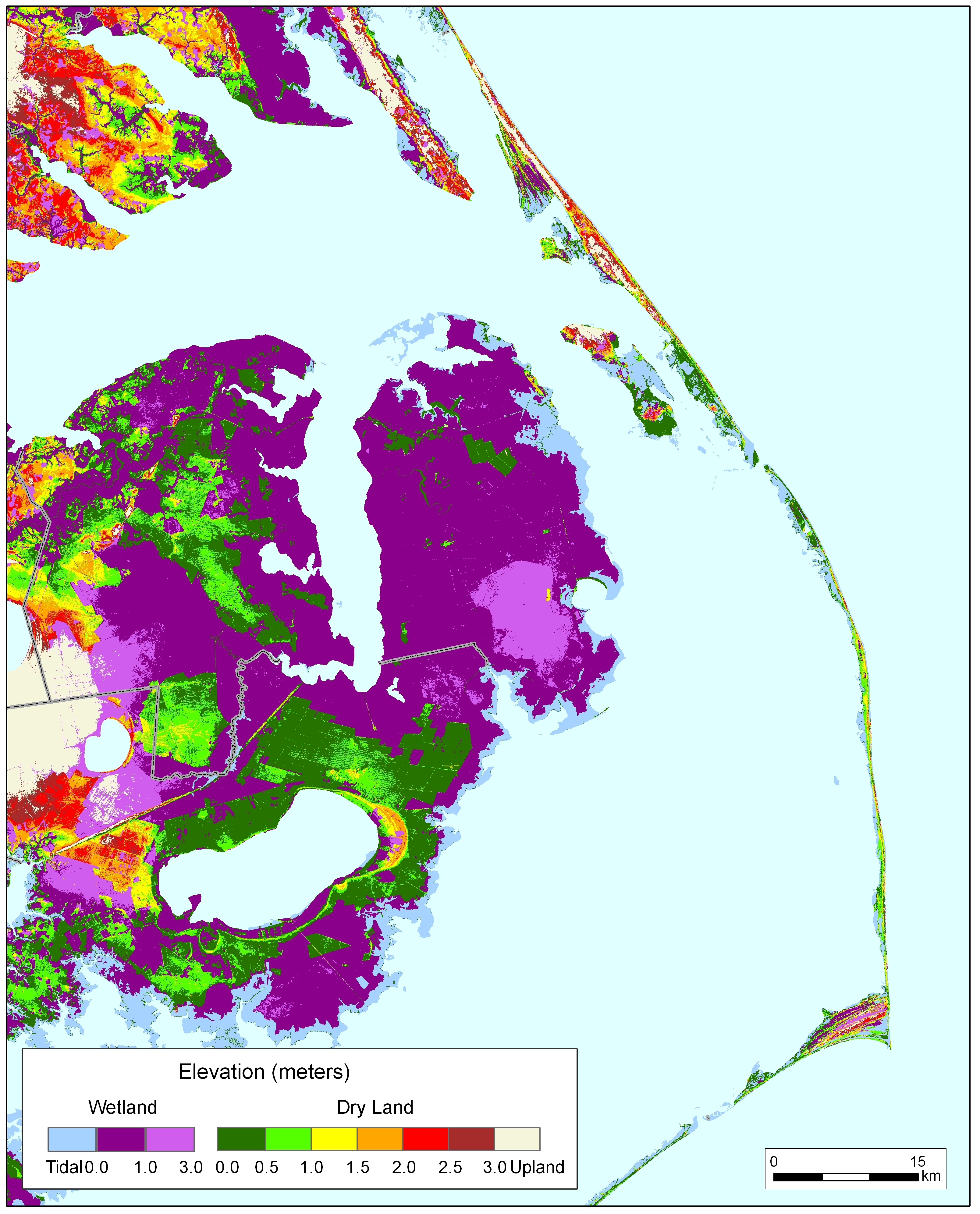
On a whim, while running the GIS figures for coastal erosion, I took a look at what was happening west of Manteo. While my class was focused on the islands (and Manteo, specifically) I GIS-ed my way towards the Albemarle Sound and the inland land masses. Caculating just for sea level rise (and not adding in the average 50 to 100 feet of land lost for every foot of sea-level rise), I produced these maps:
 (50-yr Sea Level Rise)
 (100-yr Sea Level Rise)
My professor's were stunned. The increase in the Sound size was highly unexpected, and not mention, none of our previous research and literature suggested that this was going to happen (indeed, all of our maps regarding Dare County coastal flooding/land loss were focused on the coast not the inland). Suddenly, we were not just dealing with your typical million dollar vacation-home, beach-property, bird-sanctuary, tourism-industry 'global warming' problem. We were dealing with the potential loss of valuable farmland, nonriverine peatland, permanent residences, highway/bridge developments, and the relocation of 100,000+ residents 60 miles inland from the initial study site. All set to occur within the span of 100 years.
If we thought our first case scenario was challenging...this was definitely a new story. Questions became more stressed and confounding. For example: even if we did build a sea wall strong enough to protect island residences from savage hurricanes and sea level rise, how in the world would tourists get to their vacation homes when it would mean constructing a 60 mile bridge? How would we feed these tourists when all the local farms were sitting under the new Sound? How and where would we provide water and electricity to these islands?
The cost estimates of all our plans and disaster scenarios easily cleared billions and trillions of dollars. By the end of our 5-week assignment, everyone was exhausted from the stress of trying to confront and deal with a million different economic and ecological landscape woes. Even the hardcore environmentalists among us were ready to take a break and move on to planning something--ANYTHING--other then the North Carolina-version of Atlantis. We wanted to do something cute, easy, and short-term. Like a golf course or a playground slide.
However, this one assignment definitely had a long-lasting impact on me. Climate-induced sea level rise is a problem that is going to affect a lot of people. Even people who do not live near the ocean are in imminent danger. Our ways of life, communication, and perception need to change immediately, so that we can begin to fully envision and perceive the change that is upon us.
It's only when we know the full scope of the problem that we can truly begin to resolve it.
Today, on Blog Action Day, I encourage you to take the first step in understanding how vast this problem is, and how vast our global response must be.


No comments:
Post a Comment